


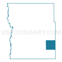
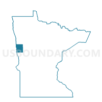
Parke Twp. Voting District, Clay County, Minnesota
About
Outline

Summary
| Unique Area Identifier | 601521 |
| Name | Parke Twp. Voting District |
| County | Clay County |
| State | Minnesota |
| Area (square miles) | 36.04 |
| Land Area (square miles) | 34.14 |
| Water Area (square miles) | 1.90 |
| % of Land Area | 94.73 |
| % of Water Area | 5.27 |
| Latitude of the Internal Point | 46.76660340 |
| Longtitude of the Internal Point | -96.22935820 |
Maps

Graphs
Select a template below for downloading or customizing gragh for Parke Twp. Voting District, Clay County, Minnesota


Neighbors
Neighoring Voting District (by Name) Neighboring Voting District on the Map
- Cormorant Twp. Voting District, Becker County, MN
- Eglon Twp. Voting District, Clay County, MN
- Hawley Twp. Voting District, Clay County, MN
- Humboldt Twp. Voting District, Clay County, MN
- Lake Park Twp. Voting District, Becker County, MN
- Scambler Twp. Voting District, Otter Tail County, MN
- Skree Twp. Voting District, Clay County, MN
- Tansem Twp. Voting District, Clay County, MN
Top 10 Neighboring County Subdivision (by Population) Neighboring County Subdivision on the Map
- Cormorant township, Becker County, MN (1,039)
- Eglon township, Clay County, MN (508)
- Parke township, Clay County, MN (485)
- Lake Park township, Becker County, MN (481)
- Scambler township, Otter Tail County, MN (476)
- Hawley township, Clay County, MN (474)
- Humboldt township, Clay County, MN (275)
- Tansem township, Clay County, MN (259)
- Skree township, Clay County, MN (159)
Top 10 Neighboring Unified School District (by Population) Neighboring Unified School District on the Map
- Pelican Rapids Public School District, MN (7,434)
- Lake Park Audubon School District, MN (4,901)
- Barnesville Public School District, MN (4,455)
- Hawley Public School District, MN (4,077)
Top 10 Neighboring State Legislative District Lower Chamber (by Population) Neighboring State Legislative District Lower Chamber on the Map
- State House District 9B, MN (39,347)
- State House District 2A, MN (37,063)
- State House District 10A, MN (35,993)
Top 10 Neighboring State Legislative District Upper Chamber (by Population) Neighboring State Legislative District Upper Chamber on the Map
- State Senate District 9, MN (81,765)
- State Senate District 2, MN (76,807)
- State Senate District 10, MN (73,591)
Top 10 Neighboring 111th Congressional District (by Population) Neighboring 111th Congressional District on the Map
Top 10 Neighboring Census Tract (by Population) Neighboring Census Tract on the Map
- Census Tract 302.02, Clay County, MN (4,528)
- Census Tract 4509, Becker County, MN (3,094)
- Census Tract 9601.03, Otter Tail County, MN (2,178)